In remote regions of the Arctic, Antarctica, and the Australian outback, an explorer can trek across bleak, uninhabited landscapes only to suddenly stumble upon ground decorated with weird patterns. These lonely sites feature ankle-high and meter-wide donuts of gravel; mazes, stripes, and polygonal networks of pebbles, sand, or ice; and sometimes ice crevasses in perfect geometric patterns. The enigmatic configurations, seemingly created without human influence, call to mind the mysterious phenomenon of crop circles, except that the puzzling structures are made of rocks or ice instead of trampled corn or wheat.
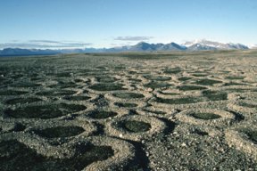
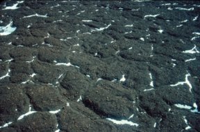


Scientists studying so-called patterned grounds have developed geological models for how some of these varied landforms have arisen from the influence of only soil, water, and sunlight. Although such simulations do a good job of reproducing Earth’s variety of patterned ground, one of them may also go much farther: It could explain the hundreds of patterned regions that spacecraft have spied on the surface of Mars.
Sorting it out
Water expands about 10 percent when it freezes, which explains why ice floats and why cans of soda explode in the freezer. It also suggests how water can be so destructive. When its molecules begin assembling into ice’s open, crystalline structure, their expansion can transform small cracks in the highway into monster potholes.
That expansive force also plays a prominent role in the geological processes that probably account for much of the world’s patterned ground, says Mark A. Kessler, a geologist at the University of California, Santa Cruz. One phenomenon, called frost heave, is the expansion that occurs when wet, fine-grained soils freeze. If rocks are scattered throughout such soils, repeated episodes of freezing and thawing brings the stones to the surface because damp soil particles gradually flow around and settle under the stones.
Another phenomenon of freezing soil moves pebbles around once they’re at or near the surface, Kessler contends. For one thing, because soil holds water but stone doesn’t, stone-poor areas have more water and expand more than stone-rich areas do.
Also, the boundary between the freezing soil above and the wet soil below moves down from the surface more quickly in stone-rich areas. Lateral forces stemming from both these actions tend to push stones toward each other.
Once frost heave has thus corralled the stones into clusters, it squeezes those clusters into piles or mounded stripes, says Kessler. Over time, the repeated freeze-thaw cycles sculpt the rock groups and smooth out any irregularities—odd-shaped piles eventually become round in top view, and linear formations take on a uniform width and height. If frost heave ends up stacking rocks too steeply, miniavalanches change the formations accordingly.
While at the University of California, San Diego, Kessler and his colleague Bradley T. Werner developed a computer model that simulates the interactions among the three processes: the lateral sorting of rocks into groups, further squeezing of those groups, and gravity-induced miniavalanches. By adjusting certain parameters in the model, Kessler and Werner reproduced the full range of stone patterns that make up what scientists call sorted patterned ground. They describe their results in the Jan. 17 Science.
When only a few stones—about 100 per square meter—were scattered across the pair’s cybertundra, frost heave shaped them into small heaps. If large quantities of the centimeter-size stones were available—up to 1,400 stones per square meter—the model produced donutlike circles. An intermediate supply of rocks typically produced networks of polygons or labyrinthine mazes of connected stripes. Other factors in the model also affected the shapes created by frost heave. For instance, formations on sloping ground tended to stretch into oblong shapes with the longest dimension pointing downhill.
Before Kessler and Werner’s model, scientists had struggled for almost a century to identify the geological processes responsible for sorted patterned ground, says Daniel H. Mann of the University of Alaska in Fairbanks. Through the years, lab and field experiments confirmed some notions, but none of the purported mechanisms could generate the full variety of patterns seen in nature.
One problem, says Mann, was that scientists were trying to model the physical interactions affecting individual grains of silt, sand, and pebbles. Another hurdle was a lack of computer power required to simulate and track the three-dimensional movements of thousands of rocks through hundreds of freeze-thaw cycles. “There’s nothing in the physics of a shovelful of stony mud that can predict the emergence of an intricate pattern of rock formations that can cover many square meters,” Mann notes.
Kessler and Werner’s computer model often needed several hundred freeze-thaw cycles for sorted patterned ground to develop from an initial random scattering of stones.
In high-latitude regions, where the ground may thaw only a few times each year, sorted patterned ground may take centuries to arise, according to the model. At sites where freeze-thaw cycles occur frequently, stone formations may form in just a few years.
Some such fast-forming patterns grace terrain once covered by glaciers near Jotunheimen, Norway. Lichens on some of the rocks left behind by the melting ice streams indicate that the glaciers began retreating in about 1750. That’s around the end of an extended cool spell that scientists call the Little Ice Age, says Jason Haugland, a geologist at the University of Colorado in Boulder.
The freshest areas of sorted patterned ground, those closest to the edge of the retreating glacier, have formed in just the past 10 years or so and are still active, says Haugland. Zones of stone patterns farther from the ice margin have become stabilized by vegetation that’s taken hold along the polygons’ stony borders. Haugland described his findings in March at the annual meeting of the Association of American Geographers in New Orleans.
Cracking up
Although rocks are necessary to produce sorted patterned ground, other types of designs can form in stonefree soils. Certain types of soil shrink significantly when they undergo big changes in temperature or when they lose moisture. That’s what happens on a small scale when the wet clays and silts along the shore of an evaporating lake desiccate and break into polygonal blocks a few centimeters across and separated by wide cracks.
The same process happens on a large scale during dry winters in soils that overlie permafrost, such as some in Alaska and Canada’s Northwest Territories. When spring rains return or the annual thaw occurs, water runs into the fissures between polygonal soil clumps that can measure tens of meters on a side. The water freezes when it comes into contact with the permafrost at the bottom of the fissure.
Eventually, a wedge of ice grows in the gap. Some of these wedges reach Earth’s surface and the cracks become semipermanent features in the terrain.
A similar process created patterned ground long ago in the western portions of New South Wales, Australia. Fine-grained, windblown soils that accumulated there in the past 1.8 million years are rich in a clay that shrinks and swells as it loses and absorbs moisture. In this region, windblown sand, dust, and other material fills the crevasses that form when soils dry and shrink, leaving an indelible pattern.
Yet farther south, Beacon Valley, one of the dry valleys of Antarctica, sports an unusual ground pattern—this one, over ice. Across a broad area of the valley floor, a 25-to-80-cm-thick layer of rocky rubble lies atop an ancient glacier. Polygonal areas ranging from 9 m to 35 m on a side are surrounded by rocky troughs as much as 3 m deep and 6 m wide, says David R. Marchant, a geologist at Boston University.
Beacon Valley’s climate is harsh. The area gets less than 10 millimeters of precipitation per year. And, based on temperatures measured at nearby Lake Vanda, scientists estimate that Beacon Valley’s average annual temperature is –34°C.
Even at the height of summer, when there’s 24-hour-a-day sunlight, soil temperatures in the valley probably rise only to a point just below freezing, says Marchant. That means the patterned valley floor probably wasn’t formed by repeated freeze-thaw cycles. In the June 2002 issue of the Geological Society of America Bulletin, Marchant and his colleagues, who have dug more than 100 trenches across the patterned ground’s troughs, presented a model that describes how the Beacon Valley polygons might have formed.
Even though the rubble layer tends to insulate the underlying glacier, temperatures along the ice’s upper surface vary significantly between summer and winter, Marchant notes. That variation, especially the sudden chill during the onset of winter, can cause cracks to form in the glacial ice. As the cracks widen, sand, grit, and small rocks from the overlying rubble trickle down into the fractures.
Because cold, dry air can then reach the glacier by seeping through newly opened spaces between larger, undisturbed stones, the rubble directly over cracks loses its insulating value.
Although temperatures along the cracks may never rise above freezing, the ice begins to sublimate, or move directly from solid form to a vapor. That makes the cracks grow wider and deeper, permitting larger stones to pour in. In a process that continues in the valley today, cracks become rock-lined troughs and form a network of furrows that surround stable, rubble-capped polygons.
Once the troughs become deep enough to collect blowing snow, they typically stop growing. That’s because even the small amount of snow available can fill the air gaps between the large stones lining the trough and restore some measure of insulation, preventing the sublimation of ice from the glacier. Deep, rock-filled troughs that have collected snow are still distinguishable from the stable, flat-topped polygonal blocks.
Several lines of evidence support the model, says Marchant. First, the team’s excavations have provided a look at the complete life cycle of a typical trough.
One feature of mature troughs is a fresh layer of ice that forms when snow that had collected there evaporates in the summer, is pulled down through the air gaps between the stones, and then solidifies atop the ancient glacial ice. The ratio of oxygen isotopes in the fresh ice is different from that in the glacier’s ice, a sign that the ice layer condensed from vapor in the trough and wasn’t originally glacier ice.
The concentration of radioactive helium-3 isotopes in the rocks exposed by a small landslide in one trough suggests that the slump occurred about 1.2 million years ago. Those isotopes are generated when the stones, open to the elements, are struck by cosmic rays. Similar chemical analyses indicate that some of the ice polygons are up to 4 million years old.
But those studies may not have found the oldest troughs and polygons, says Marchant. Analyses of volcanic ash in the rubble atop the glacial ice show the material is at least 8.1 million years old.
The great age of the ice is exciting for a number of reasons. Most importantly, says Marchant, the glacier beneath the rubble has to be older than the rubble atop it. Samples of gases trapped in layers of precipitation that fell 3 million to 4 million years ago, if they still exist and can be recovered from the glacier, could give scientists insight into what Earth’s atmosphere was like at a time when the planet’s climate was around 3°C warmer than it is today.
This new, thawfree explanation of patterned ground in the cold, dry conditions of Antarctica may also apply to similar polygonal patterns on Mars.
Probes taking images from Martian orbit have spied at least 600 different sites at which polygons measure between 30 m and 200 m on a side, says Rachel L. Klima, a geologist at the University of Illinois at Chicago. So far, more than 80 percent of the total area of patterned ground discovered on Mars is in regions where the Odyssey probe measured large amounts of hydrogen buried just beneath the Martian surface at southern latitudes (SN: 6/8/02, p. 355: Available to subscribers at Odyssey’s Homer: Hints of water near both poles of Mars). Scientists studying those data suggest that the hydrogen is associated with frozen water deposits.
That strongly suggests that these areas of patterned ground have a glacial origin, says Klima.
However, most of the polygonal patterns found in Mars’ northern hemisphere occurs in Utopia Planitia, a region in which Odyssey didn’t find large amounts of subsurface hydrogen. Nevertheless, Klima believes that the Antarctic-style cracking of a buried glacier probably formed the polygonal features there, too.
Other possible causes of the formations, including the desiccation of soils or the cooling of lava, don’t fit the observations, Klima notes. It’s possible, she says, that subsurface ice in the area formed patterns and then sublimated long ago.
Astronomers estimate that the terrain there is 3.5 billion years old.
The apparent lack of subsurface water at Utopia Planitia doesn’t disturb James W. Head, a planetary geologist at Brown University in Providence, R.I. Odyssey can detect only hydrogen that’s within 1.5 m or so of the surface. That’s only a little thicker than the rubble covering the Beacon Valley glacier in Antarctica, Head points out. So even at Utopia Planitia, hidden ice could still be patterning the Martian landscape.
****************
If you have a comment on this article that you would like considered for publication in Science News, send it to editors@sciencenews.org. Please include your name and location.
To subscribe to Science News (print), go to https://www.kable.com/pub/scnw/
subServices.asp.
To sign up for the free weekly e-LETTER from Science News, go to http://www.sciencenews.org/subscribe_form.asp.
