Pearls Unstrung
For a while, the Great Lakes weren’t connected by rivers and Niagara Falls was just a trickle
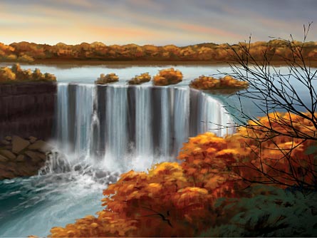
The thundering roar at the base of Niagara Falls is awesome indeed. On an average summer day, about 40 million gallons of water spill over the half-mile–wide Canadian portion of the cataract each minute. After falling over a cliff taller than a 16-story building, water pummels the rocks below, incessantly eroding the base of the cliff and triggering rockfalls. Before the 20th century, when engineers weakened the Niagara River by diverting some of its flow to produce hydroelectric power, the falls marched upstream an average of more than a meter per year.
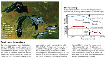
Niagara Falls is one of the last links in an impressive chain: Water flows from Lake Superior and Lake Michigan to Lake Huron, onward to Lake Erie, then down the Niagara River and over the falls to Lake Ontario and thence to the sea. Today the falls seem unstoppable, but scientists have learned that there was a time after the most recent ice age when Niagara Falls was a mere trickle and the Great Lakes were a little less great.
During the ice age, which began about 100,000 years ago, a kilometers-thick ice sheet smothered the region. And Niagara Falls — or the ice-covered cliff that would become the falls —was located several kilometers downstream of its current site. Sometime around 13,000 years ago, the ice retreated northward, leaving meltwater to accumulate in gouges that were left behind.
With the first flush of meltwater, lake levels rose and the falls raged. Studies show that as ice retreated and climate dried, however, the falls slowed to a trickle for several millennia, starting about 10,000 years ago. Scientists once thought that the falls slowed because the overflow from Lake Erie was rerouted to a different spillway when the landscape tilted and shifted as it was relieved of its icy burden. But now they are learning that some of the rivers connecting one lake to another simply disappeared during a long dry spell that started about 12,500 years ago.
In the last decade or so, scientists have uncovered clues that the water level in Lake Erie — and indeed, the levels in at least some of the other Great Lakes — fell well below all natural outlets, rendering those lakes isolated bodies of water.
New studies, including archaeological surveys and genetic analyses of fish, bolster the notion that today’s submarine ridges and nearshore shallows were once land bridges and lakeside beaches.
Ups and downs
Today, even small fluctuations in lake levels can have a big effect on the region. In a good year, vessels from the United States, Canada and other nations transport more than 200 million tons of iron ore, coal and other cargo on the lakes, says Glen Nekvasil, vice president of the Lake Carriers’ Association, based in Rocky River, Ohio. For every inch (2.5 centimeters) that lake levels drop, he says, the 65 vessels represented by the trade group must forgo carrying about 8,200 tons of cargo.
Instruments have tracked Lake Erie’s water level only since the mid-1800s, but in that time the level has, according to modern standards, fluctuated substantially. From 1900 to today, the lake’s surface altitude has varied by about 1.5 meters, says Gregory C. Wiles, a paleoclimatologist at the College of Wooster in Ohio. Although many people have suspected that human activity —dredging, engineering projects and the like — caused those variations, a study reported by Wiles and his colleagues in the March 6 Geophysical Research Letters hints that natural climate cycles are largely to blame.
Today, average precipitation over Lake Erie is about 99 centimeters per year, the researchers note. But evaporation steals about 90 centimeters of that water annually; the surplus water joins the incoming flow from the upper Great Lakes and exits Lake Erie via the Niagara River, says Wiles. Water level in the lake depends on the balance between income and outgo: In spring, when snowmelt is prodigious and temperatures — and therefore evaporation — are relatively low, the lake’s level is typically at its high point for the year. In late summer and autumn, when air temperatures and evaporation are relatively high, the level sinks.
Similarly, extended dry spells across the Upper Midwest cause lake levels to fall, says Wiles. The lowest recorded water level in Lake Erie came during the mid-1930s, near the end of the driest stretch of the Dust Bowl years. High lake levels from the 1970s through the 1990s may have resulted from weather patterns that brought higher-than-normal amounts of moisture north from the Gulf of Mexico.
Data locked in tree rings offer a way to extend the precipitation record of the Midwest back in time. For example, tree ring data from forests along the Gulf of Alaska indicate that when winter sea-surface temperatures in the North Pacific were warmer than normal, the Upper Midwest received less precipitation. That, in turn, caused water levels in the Great Lakes to drop. This link alone can explain half the modern variations in Lake Erie’s level, Wiles and his colleagues report.
Other climate cycles — including El Ni±o, the warming of sea-surface temperatures in the eastern and central Pacific —influence rainfall in the Great Lakes basin as well, the researchers’ analyses concluded.
“The Great Lakes are a great dipstick of the region’s climate,” says Wiles.
And climate will help determine the lakes’ future as well. A recent report from the U.S. Global Change Research Program states that, under a business-as-usual scenario for carbon dioxide emissions, Great Lakes levels will drop substantially toward the end of this century. Between 2020 and 2100, the water level in Lake Superior will decline about 15 centimeters, the researchers estimate. Over the same time period, water levels in Lake Huron and Lake Michigan will decline almost 50 centimeters, a change that could render parts of some harbors largely inaccessible.
Wide swings
Compared with today, water levels in the Great Lakes seesawed wildly after the last ice age, including occasional big rises. And evidence also suggests that some lakes were overflowing while others were evaporating away.
In 2008, scientists reported that small spruce saplings buried high in an embankment along the northwestern shore of Lake Superior indicate that the lake’s surface rose at least several meters — drowning the region for several centuries beginning about 8,900 years ago — before levels sank again (SN Online: 10/9/08).
But most known excursions in Great Lakes water levels, including those in the eastern lakes at the same time, have taken lake surfaces lower than modern averages, says Mike Lewis, a marine geologist emeritus with the Geological Survey of Canada in Dartmouth. Sonar scans of Lake Superior’s floor show kilometers-long troughs that were scoured by icebergs at the end of the last ice age (SN: 1/6/07, p. 14). Those features, as well as long-submerged beaches revealed by other sonar studies, reveal that water levels in the lake fell at least 70 meters below the modern-day average some time in the past 10,000 years or so, Lewis notes. What are now nearshore shallows would have been exposed during that era and could have been home to villages and broad hunting grounds for Native Americans.
Sonar scans taken off the northeastern shore of Lake Erie also show relict, now-flooded beaches. And analyses of sediments extracted from one of those ancient shorelines, as well as cores drilled elsewhere in the lake, reveal new details of the lakes’ configuration after the last ice age, Lewis and his colleagues reported in Toronto in May at a meeting of the American Geophysical Union. Not only were the Great Lakes’ levels at the end of the last ice age lower than they are today, the researchers note, but also the lakes covered much less area.
The relatively shallow western regions of Lake Erie, for example, were covered by marsh plants between 14,600 and 12,900 years ago — a sure sign that this area was mostly exposed as the last ice age drew to a close and that lake levels during this interval were far lower than they are today. Sediment cores drilled from the center of the lake reveal that the accumulation of mud there decreased substantially between 12,500 and 8,300 years ago. Finally, Lewis notes, a sediment core drilled from a now-flooded beach about 30 meters below the lake’s surface indicates that mud began to pile up on that wave-eroded surface only after 8,400 years ago.
Specifically, water levels in Lake Erie were falling at the same time that overflow from Lake Huron, the nearest neighbor upstream, flowed to the sea via other routes. Today, between 85 and 90 percent of the water that flows out of Lake Erie has flowed in from the Great Lakes upstream. Dry up that source of water, Lewis says, and evaporation quickly begins to outpace the lake’s accumulation of precipitation.
About 7,600 years ago, lake sediments also began to include hemlock pollen — a sign, says Lewis, that climate became wetter and stayed that way. Accordingly, lake levels gradually rose about seven meters in the centuries that followed. Finally, about 6,300 years ago, the overflow from Lake Huron again switched southward and spilled into Lake Erie, filling it to the brim and once again cranking up the faucets at Niagara Falls.

Life in the old Great Lakes
Not all the evidence regarding water levels in the Great Lakes has come from rocks and sediments. Archaeological and genetic evidence left behind in and around the lakes supports the idea that their surfaces were once dramatically lower than they are today. This landscape would have been vastly different for animals and early people of the Great Lakes.
Earlier this summer, researchers reported that sonar and video surveys of a submarine ridge in Lake Huron revealed structures similar to those used to guide caribou by modern-day hunters in the high Arctic (SN: 7/4/09, p. 14). Between 8,300 and 11,300 years ago, the now-flooded ridge would have been a 16-kilometer–wide land bridge connecting the state of Michigan and Ontario, Canada. The find hints that other structures, possibly even the remnants of small villages, may be preserved on what was once prime lakeside real estate.
The legacy of the disconnected lakes is seen in today’s fish populations as well. Despite an apparent lack of geographical barriers between those five lakes today, fish that inhabit Lake Erie have minor mutations in their genetic code that make them genetically distinct from their kin in the other lakes.
Take, for instance, the smallmouth bass, Micropterus dolomieu. After the ice sheet covering the Great Lakes retreated, bass that lived in unfrozen rivers and other refuges — including the Mississippi, St. Lawrence, Ohio and Hudson rivers — recolonized the lakes, says Carol A. Stepien, a fish geneticist at the University of Toledo in Ohio. Those diverse origins are preserved in today’s bass, she and her colleagues reported in Molecular Ecology in 2007.
The fish in western Lake Erie are most genetically similar to those in Lake St. Clair, a small lake just upstream from there, the researchers discovered. And the fish in eastern Lake Erie are most genetically similar to those in Lake Ontario, which lies just downstream.
In the eastern part of Lake Erie, smallmouth bass are also more genetically diverse than their western companions, and fish from areas in between have intermediate levels of diversity. These trends suggest that eastern and central subpopulations of bass were geographically isolated from one another at some time in the past — a scenario also supported by sonar surveys. The data suggest that when Lake Erie was at its lowest level, around 8,800 years ago, what is today a large body of water would have been divided into two largely separate basins connected by a small waterway.
Smallmouth bass living in close proximity to each other might be expected to be genetically similar, says Stepien, because they typically don’t migrate and often spawn in the same nesting sites each year. But more surprisingly, genetic analyses of walleye —a fish that remains generally faithful to its nesting sites yet spends much of its life in open waters, mixing with walleye from elsewhere in the lake — show similar trends in diversity.
So now findings from the disparate fields of genetics and geology, with a little archaeology thrown in for good measure, seem to be telling the same story: Once upon a time the Great Lakes, today one huge system linked by rivers and straits, were disconnected pools.
“I’ve been studying the Great Lakes for a long time, and there have been many puzzles,” says Lewis, “but only now are things coming together and starting to make sense.”