Under just the right conditions, aircraft can substantially boost precipitation by seeding clouds as they fly through them, a new study reveals.

Water typically freezes at 0° Celsius, but in the absence of dust or other small particles for the water to freeze around, the droplets in clouds can remain liquid at temperatures as low as -40°. In such a supercooled state, even a tiny disturbance can trigger freezing, says Andrew Heymsfield, an atmospheric scientist at the National Center for Atmospheric Research in Boulder, Colo. Now, data suggest that aircraft passing through clouds can produce enough ice crystals to seed the clouds and trigger a small snowstorm, he and his colleagues report in the June Bulletin of the American Meteorological Society.
The team gathered their data during a research flight over northern Colorado in December 2007. While reviewing images taken by aircraft-mounted cameras, the researchers noticed a long, narrow gap in an otherwise solid layer of clouds — a hole that lined up with the flight paths of aircraft approaching Denver International Airport that day. Beneath the gap, a wall of falling snow extended from cloud level down to the ground, Heymsfield notes. Data reveal that snowfall from this unusual storm, which lasted about 45 minutes, blanketed an area 32 kilometers (20 miles) long and 4 kilometers (2.5 miles) wide to a depth of about 5 centimeters (2 inches).
Scientists had noticed before that propeller-driven aircraft triggered cloud-droplet freezing, but no one had reported significant accumulations of plane-induced snowfall, says Heymsfield. The long, slim Colorado snowstorm began about five minutes after a turboprop jet flew through the supercooled cloud north of Denver, the team’s data suggest.
When it comes to seeding clouds and triggering precipitation, almost any particle can serve the purpose. “It doesn’t matter where the particles come from,” says Klaus Gierens, an atmospheric physicist at the German Aerospace Center in Oberpfaffenhofen-Wessling, Germany. “Any ice crystal is a possible seed,” he comments. “That’s just physics.”
Scientists have for decades noted clouds with long, narrow gaps and an underlying rain of icy particles, called canal clouds, says Patrick Minnis, an atmospheric scientist at NASA’s Langley Research Center in Hampton, Va. “I’ve always suspected that aircraft were causing these holes,” he notes. “This research really strengthens that suspicion.”
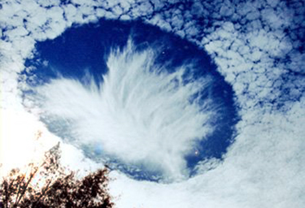
The research also implicates planes in a related phenomenon in which ice crystals falling from higher altitudes into a cloud layer trigger condensation in a spot several hundred meters across, generating a cirrus-cloudlike wisp of ice crystals inside an otherwise clear, circular gap. What’s left when those particles fall is aptly called a hole-punch cloud.
The ice crystals that triggered the Colorado snowstorm in 2007 were created in the air rushing across the front-facing surfaces of propellers, Heymsfield and his colleagues contend. As that moisture-rich air accelerated, its pressure decreased dramatically and its temperature dropped around 10 degrees C — enough to create the ice particles that then seeded the unusual snowfall. That process of condensation is the high-altitude version of the phenomenon that produces the foggy streamers shed from an aircraft’s wingtips when it flies through humid air near ground level, Heymsfield notes.
Sudden drops in pressure and temperature produce ice particles almost instantaneously, Minnis says. “Then, it doesn’t take long for the newly formed ice particles to suck up enough cloud water to gain weight and fall to the surface.”


