ROCK BOTTOM Earthquake vibrations are helping seismologists measure the depth of the ground we stand on.
Izf/Shutterstock
Earthquake vibrations are revealing just how deep the continents beneath our feet go.
Researchers analyzed seismic waves from earthquakes that have rocked various regions throughout the world, including the Americas, Antarctica and Africa. In almost every place, patterns in these waves indicated a layer of partially melted material between 130 and 190 kilometers underground.
That boundary marks the bottom of continental plates, argue Saikiran Tharimena, a seismologist at the University of Southampton in England, and colleagues. Their finding, reported in the Aug. 11 Science, may help resolve a longtime debate over the thickness of Earth’s landmasses.
Estimating continental depth “has been an issue that’s plagued scientists for quite a while,” says Tim Stern, a geophysicist at Victoria University of Wellington in New Zealand, who wasn’t involved in the work. Rock fragments belched up by volcanic eruptions suggest that the rigid rock of the continents extends about 175 kilometers underground, where it sits atop slightly runnier material in Earth’s mantle. But analyses of earthquake vibrations along Earth’s surface have suggested that continents could run 200 or 300 kilometers deep, very gradually transitioning from cold, hard rock to hotter, gooier material.
That disagreement may exist, Tharimena says, because to study continental thickness, seismologists had previously analyzed fairly shallow earthquake vibrations that couldn’t show Earth’s structure in fine detail at depths greater than about 150 kilometers.
Story continues after diagram
Bouncing back
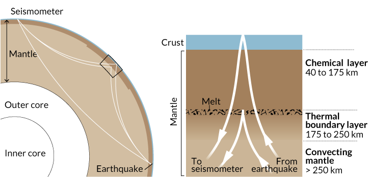
Seismic waves take different routes from an earthquake to a seismometer. Some travel deep through Earth’s mantle. Others reflect off a layer of melt in the upper mantle or bounce off the underside of Earth’s surface. By clocking the time it takes these reflected waves to arrive, scientists say they can discern the depth and consistency of a layer of slightly runnier rock that marks the bottom of continental plates.

Tharimena’s team looked at waves that bounced off boundaries between different layers in Earth’s upper mantle and other waves that ricocheted off the underside of the planet’s surface before ultimately reaching the same seismometer. By measuring how long it took for each kind of wave to reach the seismometer, the researchers could map the depths and consistencies of different layers of materials in the continental plates.
The data revealed a sharp transition from rigid rock to slightly mushier material at a depth that was fairly similar for all the continents. For instance, the melt starts about 182 kilometers under South Africa and about 163 kilometers under Antarctica. This is about as deep as diamonds — thought only to reside within continents — are known to exist, leading researchers to conclude this partially melted layer marked the bottom of the continents.
Getting this global estimate for continental thickness is “a big deal,” says Brian Savage, a geophysicist at the University of Rhode Island in Kingston who wrote a commentary on this study in the same issue of Science. The finding could help scientists make better simulations of plate tectonics, which could provide insights into what Earth looked like in the past and what it might look like in the future.


