WASHINGTON — Lightning and tornadoes can strike fear into the hearts of Americans, but they don’t strike everywhere equally. New analyses presented April 15 at the annual meeting of the Association of American Geographers find that some parts of the country are more disaster-prone than they’re commonly given credit for, while others get off easier than previously thought.

Big cloud-to-ground strikes might be expected to be most common in urban areas, for example, where large buildings could draw lightning, said Heather Sheffield of the University of Maryland in College Park. Huge skyscrapers such as the Empire State Building in New York City act as “big lightning rods,” she says.
To test that idea, Sheffield analyzed summer strike patterns from 2004 to 2008 for Maryland — a diverse state in terms of terrain. Sheffield mapped lightning flash data from the National Lightning and Detection Network over forests, cities, woody wetlands and crop regions.
To her surprise, for three of the five summers lightning struck urban settings the least. In 2007, for instance, 500 lightning strikes hit forests, while 359 struck developed land. Deciduous forests often bore the brunt. Sheffield speculates that tall trees in forests may be drawing the lightning, while the urban areas studied don’t have comparably tall buildings. Maryland’s cities “aren’t known for their skyscrapers,” she says.
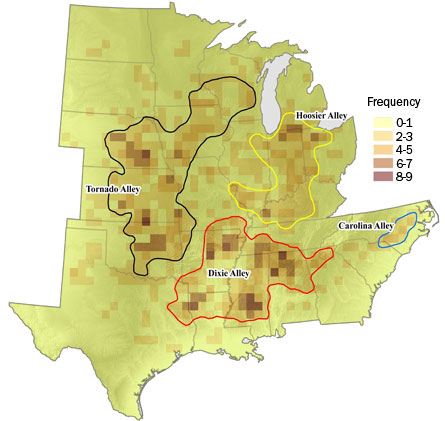
Another weather menace, tornadoes, are commonly thought to focus their destruction on “Tornado Alley,” a stretch of land that spans Texas and Oklahoma. But new research finds that tornadoes actually have several other playgrounds across the eastern United States.
Michael Frates of The University of Akron in Ohio points out that there’s no official reason why Tornado Alley is so named. He analyzed devastating F3 to F5 tornadoes with tracks of 20 miles or longer that hit the southern and eastern United States from 1950 to 2006 and found three other “alleys,” one of which is even busier than the original.
Earlier studies have analyzed tornado distribution by county. Frates instead divvied up the map into grid cells all of the same size, a method that he says provides greater resolution and catches more of the nuances of geography.
Dixie Alley, centered over Mississippi and northern Alabama, beat out Tornado Alley in tornado number, Frates found. Over the 56 years examined, an average of 2.92 tornadoes hit each cell in Dixie Alley, followed by an average of 2.59 tornadoes in each cell of Tornado Alley. Second and third runners-up are Hoosier Alley (Indiana) and Carolina Alley (centered over both Carolinas).
The two top tornado-prone regions have different storm patterns: Tornadoes tend to strike Dixie Alley all year round, while Tornado Alley’s peak season is only four months long. Frates would like to incorporate data such as the number of deaths and the amount of property damage caused by tornadoes in the two regions, particularly since warning systems aren’t as advanced in Dixie Alley as they are in Tornado Alley. He hopes the new study will make people “more aware that more tornadoes occur in areas other than Tornado Alley.”


