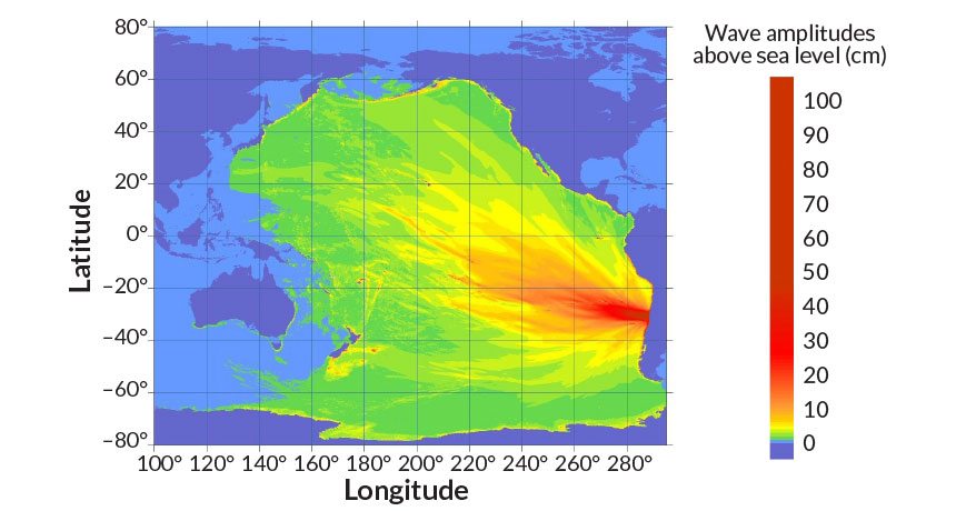
WAVE RACE A magnitude 8.3 earthquake struck September 16 off the coast of Chile, triggering a tsunami that radiated across the Pacific Ocean (projected here using existing methods). The event proved an unexpected test of new numerical calculations that can provide faster tsunami predictions.
National Tsunami Warning Center/NOAA
The deadly magnitude 8.3 earthquake off the coast of Chile on September 16 sent an enormous pulse of water racing away from the quake’s epicenter, prompting an evacuation of more than 1 million Chileans. This surging seawater provided an unanticipated test for a new, faster way to forecast quake-generated tsunamis.
Using simplified mathematical estimates of how earthquakes trigger tsunamis, researchers correctly approximated the height of the Chilean tsunami in a matter of seconds after earthquake data flowed in. When paired with upgraded earthquake-sensing technology, the technique could deliver accurate tsunami forecasts in half the time of current methods, the researchers reportin a paper to be published in the Journal of Geophysical Research: Solid Earth.
Faster predictions will help emergency managers quickly dispatch resources to areas most likely to be devastated, says Sebastián Riquelme, a seismologist at the University of Chile in Santiago. “With our model, you’ll know where the damage will likely be within five minutes after the earthquake occurred.” A tsunami’s height partly determines how far inland waters will flood.
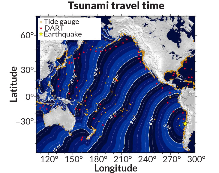
Earthquakes frequently rattle Chile, which sits a few kilometers from a seismic hot spot beneath the Pacific Ocean. In the southeastern Pacific, the Nazca tectonic plate slips under South America at a rate of about 65 to 80 millimeters each year. Occasionally, a section will suddenly shift and cause an earthquake. The abrupt movement displaces seawater like a stone hurled into a pond, creating tsunami waves that can travel at speeds akin to a commercial airliner.
In Chile, tsunamis can reach the coast 15 minutes after an earthquake, providing little time to predict how high the surging waters will rise, Riquelme says. A tsunami’s size depends on the characteristics of the earthquake responsible. For powerful tremors, however, local seismometers go off the charts and stop providing usable data. Seismologists must wait for the earthquake waves to travel farther away from the epicenter to get accurate readings, costing valuable minutes.
Some tsunami forecasts forgo this detailed earthquake data and instead calculate possible scenarios in advance. When an earthquake occurs, seismologists search a premade list for a close match. This method provides fast, though generalized, predictions.
Story continues after graph
Soon, however, GPS networks that can measure the strongest shakes could supplement seismometers (SN: 9/5/15, p. 14). (GPS stations can gauge quake strength by measuring how much the ground shifts.) Once in place, seismologists could potentially calculate earthquake properties in a matter of minutes. With such rapid earthquake data on the horizon, tsunami forecasts needed a speed boost to keep up.
Riquelme and colleagues traded accuracy for speed. While many existing tsunami predictions rely on complex simulations, the researchers instead crafted a simple mathematical method. Using the properties of a just-occurred earthquake, the system estimates the amount of displaced water and forecasts the height of the resulting tsunami — all in about 15 seconds.
The Chile quake provided the first real-time test of the team’s new method. The researchers predicted a maximum tsunami height of 5 to 6 meters, numbers that closely match early reports of a 4.75-meter swell. “We’re ready for when the GPS networks get put in place,” Riquelme says.
The method provides fast results, but its simplicity goes too far, says Eddie Bernard, a tsunami scientist emeritus at the National Oceanic and Atmospheric Administration’s Center for Tsunami Research in Seattle. Earthquakes often trigger underwater landslides that produce even larger tsunamis than the initial tremor, he says. “You can’t just do some mathematical magic and say this is what’s happening on the seafloor.”


