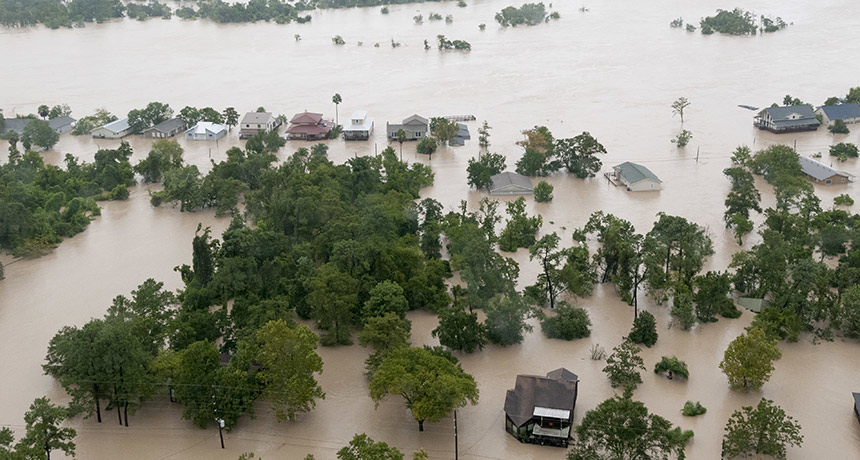
THE WEIGHT OF WATER By measuring how the land morphed daily under Hurricane Harvey’s floodwaters in Houston, scientists were able to calculate the weight of the water — and how it eventually evaporated or flowed out to sea.
AMFPhotography/Shutterstock
By mapping how downpours cause Earth’s crust to sag and swell, scientists may one day better forecast floods.
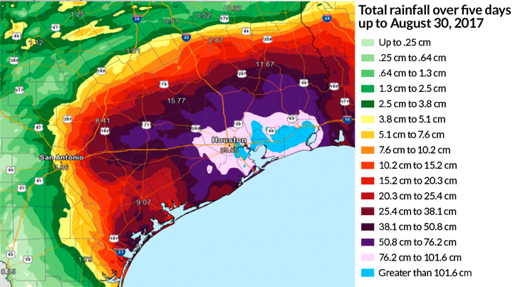
When Hurricane Harvey struck the southern United States in August 2017, it crushed rainfall records and doused the region with roughly 95 cubic kilometers of water, leaving cities like Houston inundated. Using daily elevation data from 219 GPS stations along Harvey’s path, scientists traced the rise and fall of Earth’s surface. “The idea was to try to provide a new approach to tracking storm water,” says Christopher Milliner, a geodesist at NASA’s Jet Propulsion Laboratory in Pasadena, Calif.
The weight of the water caused some parts of the Gulf Coast to sink by as much as 21 millimeters and then rebound, depending on how quickly the water flowed away or evaporated, Milliner and his colleagues report online September 19 in Science Advances. Such tracking could aid future predictions for how floodwaters might move and where they might pool.
Meteorological forecasts already reliably track where large amounts of rain fall, helping communities prepare for potential flooding. But these forecasts can’t always predict where that water will go or how it will impact area waterways. So Milliner’s team started with a question: “Once Harvey deposited that water, what happened to it?”
The weight of Harvey’s floodwaters caused fluctuations in the height of Earth’s surface. Surveying this crustal deformation indicated exactly where the water pooled as the hurricane passed overhead, and helped researchers calculate the weight of the water. The team found that the GPS network recorded a trail of land sinking beneath the weight of the rain after Harvey made landfall in Texas, curved back out to sea and then made landfall a second time along the Texas-Louisiana border.
During the storm, 25 cubic kilometers of water — about the volume of Vermont’s Lake Champlain — pooled in neighborhoods surrounding Houston. In the days after Harvey, much of the sunken land rebounded as the water flowed toward the sea at a rate of 8 cubic kilometers per day. Then, in the following five weeks, nearly 1 cubic kilometer of groundwater was lost to the atmosphere through evapotranspiration each day, further spurring a slow rise in Earth’s crust. Milliner says he and his team were surprised the GPS networks were able to capture the gradual uplift.
GPS systems have been used to track crustal deformation for decades, but usually on monthly or annual timescales. For instance, scientists have calculated the rate of subsidence and uplift in California’s Central Valley during the 2011–2017 drought, and have charted the weight of snowpack in the Himalayas. Scientists have also used field surveys, optical images and other satellite systems — such as the Gravity Recovery and Climate Experiment, or GRACE, satellites that track changes in Earth’s gravity — to chart crustal deformation.
Milliner’s team “processed the data really rapidly,” says Estelle Chaussard, a geodesist at the University at Buffalo in New York, who was not involved with the study. “This could become something that we could use in short time spans to try to help the response and better understand where the floodwater is going.”
The next step is to test this method against smaller storms, Milliner says. Because Harvey dumped so much water, it was relatively easy to measure. He’d like to ensure the technique is sensitive enough to map out areas doused by storms that carry less rain but still have potential to cause flooding problems.


