World’s climate map gets an update

Scientists have added modern weather data to a century-old classification of the world’s climates to provide more accurate comparisons between the results of computer simulations and terrestrial reality.

RED STATE, BLUE STATE. The most widespread of the world’s climate types are hot desert (red) and tropical savannah (light blue). Peel, et al.

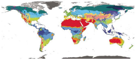
The Köppen-Geiger system of climate classification—named after the researcher who formulated the scheme and another who later enhanced it—was developed in the late 1800s. It assigns the climate at any site to one of five general categories—tropical, arid, temperate, cold, or polar—and adds finer subdivisions according to annual variations in temperature and precipitation.

Despite numerous attempts to develop better classification schemes, the Köppen-Geiger system has remained the most popular among teachers and scientists, says Murray C. Peel, a geographer at the University of Melbourne in Australia. Much of the system’s popularity stems from its simplicity, he notes.

When the Köppen-Geiger system was developed, weather stations were widely scattered, their historical records were short, and mapping techniques were relatively crude. Peel and his colleagues updated the system by including data from more than 4,200 weather stations that have collected meteorological data monthly for at least 30 years. The team’s new map classifies climate in each 0.1°-by-0.1° square of a grid that covers the globe’s entire land area.

The most widespread type of climate is hot desert, which covers 14.2 percent of Earth’s land, the researchers report in an upcoming Hydrology and Earth System Sciences. The second most common is tropical savannah, which accounts for 11.5 percent. One of the system’s 30 possible climate subtypes—a temperate climate with a cold, dry summer—wasn’t found anywhere on Earth.


More Stories from Science News on Earth