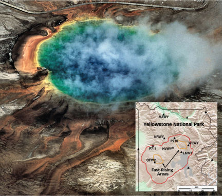
From mid-2004 through 2006, parts of the terrain in Yellowstone National Park rose as much as 7 centimeters per year, a rate about three times that previously measured. Analyses suggest that the rapid uplift results from the flow of molten rock into a Los Angeles–size zone of strata beneath the park.
Yellowstone, one of the most active hydrothermal regions on Earth, contains more than 10,000 geysers, hot springs, and steaming volcanic vents (SN: 6/5/04, p. 357). The heat fueling this activity comes from molten rock welling up beneath the park’s central basin from deep within Earth, says Wu-Lung Chang, a geophysicist at the University of Utah in Salt Lake City. The main plume of hot, buoyant material rises to depths of about 50 kilometers, he notes, but occasionally blobs of molten rock break off the plume, rise, and replenish a broad magma chamber nearer the surface.
Detailed surveys of Yellowstone began in 1923. In recent years, scientists have supplemented those efforts with data from ground-based Global Positioning System equipment and satellite-based radar, says Chang. The rise and fall of the park’s landscape reflect the immense and often complex subterranean motions of molten rock and groundwater, he notes.
Between 1923 and 1984, some spots in the basin rose, on average, about 1.4 cm/yr. Then, from 1985 to 1995, the terrain subsided almost 1 cm/yr, says Chang. In the following 6 years, the basin floor began to rise again, and an area northwest of the basin rose even faster. From 2000 to 2003, the northwestern area rose about 3.6 cm while the basin floor sank about 2.8 cm.
The Yellowstone basin’s record-setting inflation, about 7 cm/yr in some locales, began in July 2004, Chang and his colleagues report in the Nov. 9 Science. Around 3 months later, terrain to the northwest began to subside, a trend that the researchers attribute to a flow of groundwater from that area.
The team’s analyses suggest that the magma chamber beneath Yellowstone is about 10 km below the surface and underlies an area of roughly 1,200 square kilometers. From mid-2004 through 2006, about 0.1 cubic kilometer of molten rock flowed into that reservoir, says Chang.
The Yellowstone region has seen numerous volcanic eruptions, including a massive eruption about 640,000 years ago that spewed about 1,000 times the volume of lava that Mount St. Helens ejected in 1980, says Jake Lowenstern, a geophysicist with the U.S. Geological Survey in Menlo Park, Calif. The new findings, however, don’t suggest that an eruption is imminent. “The last 3 years have been seismically quiet,” he notes. Moreover, there have been no significant changes in geyser activity.
The new findings are “very fascinating” and offer scientists insights into how the park’s subterranean plumbing works, says Hank Heasler, a National Park Service geologist at Yellowstone’s headquarters in Mammoth, Wyo.
Although recent uplift in Yellowstone has been rapid, detailed observations have been available only for a few decades, notes Heasler. “Statistically, that’s not a very long time,” he says.