Shallow coral reefs around islands west of Sumatra chronicled the uplift and subsidence that resulted from massive quakes that struck that region recently, a new study shows. From data recorded in this biological database, scientists may learn why two undersea ruptures stopped where they did.
On Dec. 26, 2004, a magnitude 9.3 temblor beneath the Indian Ocean spawned killer tsunamis (SN: 1/8/05, p. 19: Tsunami Disaster: Scientists model the big quake and its consequences) and a flood of scientific interest (SN: 8/27/05, p. 136: Earthshaking Event). Researchers rushed to the affected region to install sophisticated instruments, many of them in time to record the effects of a magnitude 8.7 quake in March 2005 (SN: 4/2/05, p. 211: Available to subscribers at Hit Again: December temblor probably caused new Sumatran quakes). But some of the best sensors—the reefs surrounding the region’s islands—had been in place all along, says Richard W. Briggs, a geologist at the California Institute of Technology in Pasadena.
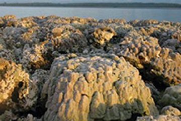
Many corals, especially those in the genus Porites, naturally record sea level. They grow to the water’s surface but can’t tolerate dry conditions for more than a few minutes. Once a mass of corals including those species reaches the sea’s surface, it stops growing taller but continues to grow laterally, says Briggs. Thus, a flat top on a Porites colony marks the previous level of a site’s lowest tide. Briggs and his colleagues surveyed reefs around islands west of Sumatra to estimate quake-induced rises and falls. They report their results in the March 31 Science.
The two quakes approached the 100-kilometer-long island of Simeulue from different directions. The island’s northwestern tip rose 1.45 meters during the December 2004 temblor, says Briggs. However, the southeastern tip of the island, farther from the quake’s epicenter, didn’t rise or fall noticeably.
In contrast, after the March 2005 quake, the island’s northwestern tip held a steady elevation, while the southeastern tip was lifted about 1.65 m.
Reefs along the midsection of Simeulue rose only 50 centimeters or so in response to the 2004 and 2005 temblors, says Briggs.
That pattern suggests that in central Simeulue, stress on the fault had been relieved by previous small quakes, including one in 2002, or during periods when the fault had slipped without causing a temblor. That stress relief might have prevented the quakes of 2004 and 2005 from progressing through this region.
Alternatively, the geometry of the fault beneath the island may have arrested the progress of the quakes’ ruptures, says Briggs.
Understanding why the Indonesian ruptures of 2004 and 2005 stopped where they did will be important for evaluating seismic risk throughout Southeast Asia, says Roger Bilham, a seismologist at the University of Colorado at Boulder.


