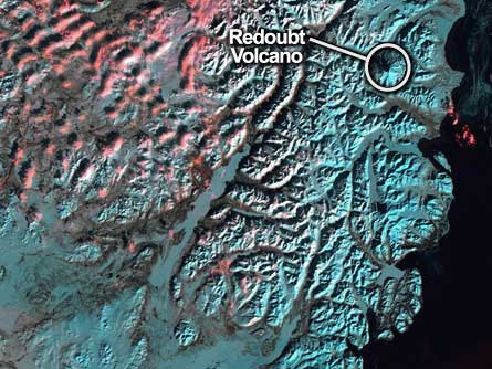
The high-flying Landsat 5 celebrated a quarter-century in orbit March 1 by snapping an image of Alaska’s Redoubt Volcano, a peak that’s been rumbling and threatening to erupt since November 2008.
Since its launch in 1984, the VW Beetle-sized craft has circled Earth at an altitude of about 700 kilometers more than 130,000 times — once every 99 minutes, says Kristi Kline, program manager for Landsat at the U.S. Geological Survey’s Center for Earth Resources Observation and Science in Sioux Falls, S.D.
Sensors on the polar-orbiting craft collect data at seven different wavelengths from near ultraviolet to the far infrared. Except for central Antarctica and far northern Greenland, the satellite passes over each spot on land once every 16 days, and can distinguish features as small as 30 meters across, Kline notes.
Besides providing before-and-after shots of landscapes that have suffered natural disasters such as volcanic eruptions, floods, tsunamis or hurricanes, the archive of Landsat data — 2.3 million images strong and gathered since Landsat 1 launched in 1972 — also chronicles the effects of human activity such as urban sprawl and deforestation.
So why has Landsat 5, originally designed to operate just three years, lasted so long? In part, because the craft was designed with extra fuel capacity so it could occasionally be brought to lower orbit and serviced by astronauts onboard the space shuttle — a feature that hasn’t been used. The fuel instead has served to keep the satellite in orbit and oriented properly. “That, plus some really good engineering and a lot of luck,” Kline adds.